30 décembre 2012

ADOT has an online tool to provide vehicle tax details

It's that time of year again...

Now that tax season is here, EZ Vehicle Fee Recap is once again available from the Arizona Department of Transportation's Motor VehicleDivision to help you prepare your 2012 income tax return. The free EZ Vehicle Fee Recap Program allows Arizona vehicle owners to view their own report of registration fees and taxes paid in the prior calendar year.

While vehicle owners are advised to consult with a tax-preparation professional or seek guidance from the Internal Revenue Service or Arizona Department of Revenue, the EZ Vehicle Fee Recap Program provides a simple report of registration fees that can be viewed or printed. To begin the easy process, the user just has to enter their name, Arizona driver license or customer identification number and follow the screen prompts. Information on ServiceArizona.com is transmitted securely using encryption technology.

“This is one of our most popular features during tax season,” said MVD Director Stacey Stanton. “We want to publicize this free service to as many customers as possible.”

Each report contains information about fees paid through the vehicle license tax, registration (personal and commercial), air quality, air quality compliance, emission in lieu, weight, motor carrier, use, postage and handling, penalty, serial number, specialty plate, transfer, processing, diesel, or Department of Revenue/sales tax.

Find the website for the EZ Vehicle Fee Recap online at: https://servicearizona.com/webapp/feeRecap/

29 décembre 2012

More community events on the schedule as ADOT continues Passenger Rail Corridor Study


If you read this blog post last month, you already know that ADOT is making a call to the public for input on the Passenger Rail Corridor Study...

You’re also aware that this study’s purpose is to examine the feasibility of a passenger rail line between Phoenix and Tucson.

But, maybe you don’t know that since we last blogged about the study, ADOT has been out to several community events talking with thousands of people (see photos above). These events have included Coolidge Days, Tucson Meet Yourself, CityScape downtown Phoenix lunch hour, Maricopa Stagecoach Days, Gilbert’s Fall Festival and the Arizona State Fair!

The community events, along with ADOT’s media and social media outreach, have yielded the following:
  • Over 1,300 online surveys completed 
  • 348 comment forms received 
  • More than 100 comments received via email or mail 

What’s next?
Comments are being accepted through Dec. 15 and there are still several community events that ADOT will be participating in through the rest of this year – find information HERE.

You can also go online to get all the information you need on the study – while you’re there, you can complete a quick online questionnaire about the potential corridor alignments.

Kidde 21005779 Pro 210 Fire Extinguisher, ABC, 160CI


Features
  • Multipurpose dry chemical; fights all types of fire (trash, wood, paper, liquids, electrical equipment)
  • Pressure gauge allows for immediate pressure status check
  • Powder coated aluminum cylinder for corrosion protection
  • Rechargeable; wall hanger included
  • Meets the requirements of Underwriters Laboratories (UL), an independent facility that tests products for compliance with widely-accepted safety standards

List Price: $108.99
Get this month Special Offer: check this out!

Related Products

Amazon.com

A multipurpose fire extinguisher for your home or business, the Kidde Pro 210 (model No. 21005779) is fitted with a pressure gauge that provides an at-a-glance status, and it features a lightweight aluminum cylinder and sturdy chrome-plated brass valve assembly.


Kidde Pro 210
Features

The Kidde Pro 210 is suitable for use on Class A (trash, wood, and paper), Class B (liquids and gases), and Class C (energized electrical equipment) fires. It's ideal for protecting your home as well as low-hazard occupancies such as offices, churches, assembly halls, classrooms, and hotel guest areas. This rechargeable unit contains four pounds of a multipurpose monoammonium phosphate dry chemical extinguishing agent. It has a discharge time of 13 to 15 seconds, a discharge range of 10 to 15 feet, and an operating pressure of 100 PSI.


ABC

The seamless aluminum cylinder is powder coated for corrosion protection, and it measures 4.5 inches in diameter and 15.7 inches tall. Assembled in Mexico from globally sourced components, it's backed by a six-year limited warranty. It comes with a plastic hanger, and it is Coast Guard (U.S.C.G.) approved when fitted with an optional mounting bracket.

What's in the Box

One Kidde Pro 210 fire extinguisher, one plastic hanger, and operating instructions.


At a Glance
Pro 210 Fire Extinguisher
At a Glance: Protects low-hazard occupancies such as homes, offices, churches, and more

Tough aluminum valve assembly

Pressure gauge allows for immediate pressure status check

Rechargeable unit

Six-year limited warranty
At a Glance


Kidde 21005779 Pro 210 Fire Extinguisher, ABC, 160CI - Amazon.com A multipurpose fire extinguisher for your home or business, the Kidde Pro 210 (model No. 21005779) is fitted with a pressure gauge that provides an at-a-glance status ... Kidde 5 BC Extinguisher* - ShopWiki ShopWiki has 314 results for Kidde 5 BC Extinguisher*, including Kidde 21005726 Fire Extinguisher,dry,abc,3a:40b:c 5mpl4, Kidde 466504 Wheeled Extinguisher, 50-Pound ... Kidde 21005782 Pro 340 Fire Extinguisher, ABC, Rechargeable ... The PRO340 is fitted with a pressure gauge that provides at-a-glance status, is manufactured from lightweight aluminum cylinder & sturdy chrome plated brass valve ... Kidde Kidde - Pro Series Fire Extinguishers 4Lb Abc Pro210 Fire ... Shop Low Prices on: Kidde Kidde - Pro Series Fire Extinguishers 4Lb Abc Pro210 Fire Extinguisher: 408-21005779 - 4lb abc pro210 fire extinguisher : Heating, Cooling ... 2a10bc Fire Extinguisher - Compare Prices, Reviews and Buy at Nextag 2a10bc Fire Extinguisher - 25 results like Kidde Pro 210 Fire Extinguisher, ABC, 160CI, Amerex B403T Fire Extinguisher,Dry Chemical,BC,10B:C, Amerex 5 Pound Abc Dry ...

26 décembre 2012

Motorola MH230R 23-Mile Range 22-Channel FRS/GMRS Two-Way Radio (Pair)


Features
  • 10-hour alkaline or 8-hour rechargeable battery life
  • 11 weather channels (7 NOAA) with alert features
  • 22 channels each with 121 privacy codes for superior interference protection
  • Pair of two-way radios with up to 23 mile range
  • iVOX hands-free communication without the need for an audio accessory

List Price: $59.99
Get this month Special Offer: check this out!

Related Products

Amazon.com
The Motorola Talkabout MH230 is a great choice for nearly any outdoor enthusiast. With a powerful range of up to 23 miles, this radio is perfect for family and friends to stay in touch, whether you're tackling a back country trail or trying to brave a crowded shopping mall. The MH230 has more than exceptional range. Tune into one of 7 NOAA channels (National Oceanic and Atmospheric Administration) on your MH230 for continuous local and regional weather broadcasting, and get real-time weather alerts to protect you from the danger of a sudden storm. The MH230 has full 22-frequency capacity with 121 privacy codes to reduce interruptions. Motorola's QT (Quiet talk) functionality allows the radios to be set so they can communicate with other compatible Motorola products.


A great choice for nearly any outdoor enthusiast. Click to enlarge.

The MH230R radio features flexible charging options for ultimate mobility. Users can choose to charge in the included dual drop-in charger, or use the mini-USB port in the radio to charge in the car or connect to a PC. For remote adventures standard alkaline batteries can be used when no power is available. Additionally, hands-free communication is available by using the iVOX speech-activated feature, which provides active families the freedom of mobility in even the most remote settings.

MH230R Features

Keypad Lock
Lock your keypad to avoid accidentally changing your radio settings.

Channel Scan
Use scan to search the 22 channels for transmissions from unknown parties, to find someone in your group who has accidentally changed channels, or to quickly find unused channels for your own use.

Charging Options
You can charge the MH230 using the Motorola standard charging port (with the included charging adapter), the Drop-in cradle charger (also included), or purchase a mini-USB cable for use with the Mini-USB charging port, especially useful when traveling.

121 Privacy Codes
Interference Eliminator Codes help minimize interference by blocking transmissions from unknown sources. The MH230 features 121 codes for superior interference protection.

Includes drop-in dual charger for easy charging.

Brilliant LCD with battery indicator, channel, and other info.

Ten Call Tones
The MH230 can transmit different call tones to other radios in your group so you can alert them that you want to talk. Choose from ten different tones.

Hands-Free Communication
Use the iVOX feature to transmit hands-free without the need for any headset accessories. Once iVOX is turned on, the radio detects your voice and transmits when you speak into the internal microphone.

QT (Quiet Talk) Noise Filtering
The QT noise-filtering feature helps to


Two-Way Radios Staples - Office Supplies, Printer Ink, Toner ... Midland Radio (LXT118VP) Two Way Radio with Charger. 22 Channels - Clear, crisp communication with easy button access; Up to 18 Mile Range; Channel Scan ... Amazon.com: Customer Reviews: Motorola MH230R 23-Mile Range 22 ... 5 stars. "Great 2-way radios!" IMPRESSION BASED ON EXPERIENCE: This is my second pair of Motorola 2-Way radios. I have tried other bands like Midland and been very ... Motorola MR350 TalkAbout 35-Mile 22-Channel FRS/GMRS Two-Way Radio ... The Motorola Talkabout MR350, with its range of up to 35 miles and bundle of great features, is a great communication tool for the serious outdoor enthusiast ... Customer Reviews for Motorola MH230R 23 Mile Two-Way Radio with 22 ... Rated 4 out of 5 by Zel1 Not bad for the price I bought these AFTER reading the reviews. I wasn't expecting a 23 mile range, or for that matter 1 mile. motorola mh230r eBay - Electronics, Cars, Fashion, Collectibles ... Find great deals on eBay for motorola mh230r and mr 350. Shop with confidence. Motorola MH230R 23-Mile Range 22-Channel FRS/GMRS Two-Way Radio (Pair) The Motorola Talkabout MH230 is a great choice for nearly any outdoor enthusiast. With a powerful range of up to 23 miles, this radio is perfect for family and ... Motorola MH230R TalkAbout 23-Mile 22-Channel FRS/GMRS Two-Way ... The Motorola Talkabout MH230 is a great choice for nearly any outdoor enthusiast. With a powerful range of up to 23 miles, this radio is perfect for family and ... Motorola MH230R Talkabout 2 Way Walkie Talkie Radio FRS GMRS New ... Motorola MH230R Talkabout 2-Way Walkie Talkie Radio FRS/GMRS NEW Yellow 23 Mile in Consumer Electronics, Radio Communication, Walkie Talkies, Two-Way Radios eBay

25 décembre 2012

ADOT ready for winter season; snow removal a priority

Winter isn’t officially here yet, but Arizona has already received some snowy weather this month.

Don’t worry … the season’s early start hasn’t caught ADOT off guard. Our crews are ready and have been preparing for winter operations all year long.

Winter in Arizona
Weather conditions in Arizona can find you driving from the sunny, moderate climate of the low desert into ice and snow in the state’s mountain regions in just a couple of hours. These types of winter storms can really cause havoc with travel plans and businesses. And it means that ADOT—and drivers—need to be prepared.

Public safety is ADOT’s top priority when winter storms hit the state and roads become snowy and icy. ADOT resources are quickly deployed before, during and after storms to keep state highways safe. ADOT’s goal is to limit highway closures and to clear snow and ice as soon as possible.

ADOT has added 16 new snowplows to its fleet this winter season to replace 16 older plows. These new plows, which cost approximately $250,000 per vehicle, are being deployed to different regions around the state.

To date, all of ADOT’s 202 snowplows are serviced and ready, 420 snowplow operators are trained and on alert, and maintenance yards are stocked with deicer materials and equipment.

The cost of winter weather 
ADOT’s yearly budget for snowplowing and winter storm maintenance is between $4 million and $8 million, depending on the severity of the winter season. Last season was particularly heavy as ADOT spent approximately $7.6 million on snow removal efforts. This figure includes labor costs, equipment expenses, fuel and deicer chemicals.

Staying safe 
While ADOT is prepared to keep the roads clear and open, the agency is encouraging motorists to be prepared as well when driving in snowy and icy conditions. Winter can be a dangerous time with wind, ice, snow and freezing temperatures causing unsafe conditions. With that in mind, ADOT recommends the following winter driving tips:
  • Slow down, be patient and drive safely. Plan for extra travel time. 
  • Be alert: ice forms on bridges first and is hard to see. 
  • When driving behind a snowplow, stay back at least a few car lengths until it’s safe to pass or until the plow pulls off the road. If you think you’re traveling too close to a plow, you probably are. Be safe and stay back! 
  • Maintain at least a three-quarter full tank of gas. 
  • Notify someone of your travel route, destination and projected arrival time. 
  • Carry an emergency preparedness kit in your vehicle that includes blankets, extra clothes, a flashlight, an ice scraper, a shovel, sand for traction, a fully charged cell phone, and hazard warning lights or reflectors. 
  • Brake slowly to avoid any panic braking or jerking the steering wheel. 
  • Increase the distance between you and the traffic ahead. 
  • Carry plenty of food and water and all necessary medications. 
  • Carry tire chains, snow cables or snow tires. 
  • Wear warm clothes to protect you during extended time periods in cold temperatures. 

Additional information on how ADOT prepares for winter weather can be found in our blog archives and at ADOT’s “Know Snow” website. The site also contains downloadable snow maps of snowplowing schedules and routes.

Before heading out on the roads, drivers are encouraged to call 511 or log on to ADOT’s Traveler Information Center at www.az511.gov for the latest highway conditions around the state. The website features images along state highways that give drivers a glimpse of weather conditions in various regions.

22 décembre 2012

Better safe than sorry: roadway departure crashes

Adhering to the
posted speed
limit is important.
By Kohinoor Kar and Mike Cynecki
Guest Bloggers

What is a roadway departure crash?
By definition, a roadway departure crash is a non-intersection crash that occurs after a vehicle crosses an edge line or a centerline, or otherwise leaves the traveled way.

However, not all roadway departures result in crashes. While a roadway departure incident in itself may not initially be harmful, the secondary events or crashes resulting from the roadway departure can be deadly.

How to avoid a roadway departure?
There may be various reasons why a vehicle departs from its lane or runs off the road. However, most times it happens due to driver error, such as speeding on a sharp curve or a steep grade (particularly on rural two-lane highways), distraction, inattention, intoxication, fatigue, nighttime visibility or vehicle issues such as tire blowouts, and some may involve roadway issues such as ponding water or icy roads. The best way to avoid a roadway departure is to always be alert, attentive and clear-headed when driving and to conduct periodic inspection and maintenance of your vehicle.

Successful measures for safe driving also include paying proper attention to the road in front of you as well as to nearby vehicles; driving at an appropriate speed for the existing roadway, traffic and weather conditions; and avoiding any kind of distraction, such as using handheld communication devices, changing a CD or radio station, setting the GPS unit while driving or engaging in intense conversations with passengers.

Approaching curves and freeway ramps
Unfortunately, many drivers approaching curve warning signs with a lower advisory speed plaque do not slow down in conformance with the advisory speed. The reason for an advisory speed is to warn the driver of a specific roadway or traffic condition recommending a need for a reduced speed. If the traffic or weather condition is not suitable for the advisory speed posted for a curve or any other roadway condition(s) on a stretch of highway, one must slow down to a reasonable speed that may even be lower than the advisory speed.

The same driving behavior is quite often observed at freeway ramps. While exiting a freeway, notice how many black tire marks are visible on the concrete barrier or ramp. It’s not necessarily the ramp design that causes drivers to run off the road. Instead, it is usually driver error that causes these impacts. Most of these crashes are due to drivers not slowing down enough prior to entering the ramp, not heeding the advisory speed or not driving consistent with the existing conditions.

Overcorrection can be deadly!
Many single-vehicle roadway departure crashes often result in serious injuries and fatalities, especially since most occur at high speeds. According to Arizona crash statistics, slightly more than 18 percent of the total crashes in 2011 were single-vehicle crashes, but these crashes accounted for more than 40 percent of the statewide fatal crashes. These numbers clearly indicate the severity of single-vehicle crashes.

Sometimes a driver is surprised by an animal that runs into the road or a vehicle that appears to be moving into their lane, which causes a reflexive action to avoid the crash. When a driver, who is travelling at a high speed and is distracted, drowsy or inattentive, runs off the road even slightly, he/she often makes an attempt to remedy the situation quickly by jerking the wheel in the opposite direction. This sudden movement of the wheel causes the car to veer to the other side, often sending the car across the roadway or causing it to roll. In fact most drivers who run off the left side of the roadway, do so after running off to the right side and overcorrecting when trying to get back onto the roadway.

To have better control of the steering wheel, you must always use both hands when driving. You will have better control of your vehicle if you think of your steering wheel as an analog clock and place your hands at the 9 and 3 o’clock (middle) positions. The 9 and 3 positions are intended to maximize the leverage on the steering wheel. Always keep both hands on the wheel. Doing so can help avoid lane departures, and if you do inadvertently run off the road, it will allow you to have better control of the steering wheel under emergency conditions. At very high speeds, depending on the roadway geometry, it may be a better option to take these steps:
  • Don’t panic. 
  • Slow down by easing off the gas pedal. 
  • Slowly apply the brakes. 
  • Safely stop on the shoulder or on the roadside as appropriate. 

The key is to bring the vehicle to a full stop rather than try to get back on the road immediately. In some cases, hitting a bush or minor objects on the roadside after an unexpected roadway departure will probably result in less of an impact and have a lower potential for serious injuries and damages.

Every roadway departure situation can be different and unique in nature. However, certain driver behaviors can save lives or prevent serious injuries and damages by always staying alert and avoiding overreaction. Preventing a roadway departure is not difficult, and common sense can help avoid life-changing incidents behind the wheel. Undoubtedly, it is always better to be safe than sorry.
-----------------------------------
Kohinoor Kar, Ph.D., P.E., PTOE, a professional engineer with 23 years of combined experience in the roadway, traffic and safety field, has been with the State of Arizona for past eight years.

Michael J. Cynecki, P.E. retired from the City of Phoenix after a career of 26 years in the Street Transportation Department, and is currently with the consulting firm of Lee Engineering, LLC.

Disclaimer: Opinions expressed in this article are those of the authors or references cited herein and may not necessarily represent the views of the agencies they are affiliated with. Information contained in this article are for general awareness only and are not intended to substitute for professional advice to any particular person or case. Some of the information might change over time in which case the current practice would supersede all previous practices.

21 décembre 2012

Work continues on US 89 landslide site


Yesterday marked one month since a landslide ripped through a segment of US 89 and buckled more than 150 feet of the pavement…

That geological event not only triggered an immediate closure of a 23-mile stretch of the highway, it also brought out a whole team of engineers and geotechnical experts to the scene.

And, while there still is no timeline for restoring the route, we can assure you that crews are working diligently at the site, inspecting the damage and examining the causes behind the slope failure – all of which you can see in the video above.

What’s been happening at the site?
Besides the geotechnical stuff – which we’ll get to in a minute – some of the work since Feb. 20 has included getting word out to drivers.

Flagstaff District Project Supervisor Rick Schilke explains that temporary traffic control was in place at first, but since then, crews have put in semi-permanent signs that mark the detours.

“About every 10 miles there’s another sign that says ‘keep going,’” Schilke said.

Earlier this month, the team also had to prepare for a storm that was forecasted to bring rain and snow to the region. You can see in the video that precautions included putting down a thick plastic liner to protect the site from water infiltration.

“We have crevices in the earth over 30 feet deep and the desire is to not have moisture in those areas because when the moisture gets into the earth, it gives it a higher chance of sliding even further,” says Flagstaff District Engineer Audra Merrick.

Now, onto the geotechnical side of things…

Core drills are being used so engineers can detect any shears that are developed underground and get a better idea of what some of the future options are.

And, we can’t forget the inclinometers – faithful ADOT Blog readers will already know about these. You can see in the video that these instruments are being used at the site so engineers can see what’s happening deep below the road’s surface.

“It can give us readings several hundred feet down,” says Kelinfelder Geotechnical Engineer Jed Stoken. “In this case we’re trying to go down about 150 feet. We think that the shears in the bedrock are probably at least 100 to 125 feet. It’s a very deep slide.”

What’s next?
As we said above, no timeline has been established and crews are still working to determine what the best long-term solution might be.

“There was some sort of geological event that occurred, obviously, up here and so we just can’t come up here and replace the road for the sake of replacing it,” Merrick says. “We need to determine what the cause was in order to best use our funds to reestablish the route.”

Luckily, there are plenty of ways for you to stay informed about the situation. Visit www.azdot.gov/US89 for the latest news, photos and videos. While you’re there, you can sign up for email updates and download a map of the closure.

19 décembre 2012

I-11 public meeting set for Oct. 23

Perhaps you’ve heard about Interstate 11?

It’s the proposed corridor pursued by Gov. Jan Brewer to create a stronger regional connection between Phoenix and Las Vegas.

Right now I-11 is still in the early planning stages – funding to construct the potential corridor has not been identified. But ADOT, in cooperation with the Nevada Department of Transportation, wants to get some input from you and is hosting a public meeting 6-8 p.m. Oct. 23 at the Burton Barr Central Library, 1221 N. Central Ave., in Phoenix.

While an exact alignment for I-11 will be determined through extensive future engineering and environmental studies, work began this summer to examine a connection between Phoenix and Las Vegas, with the potential to extend north toward Canada and south to the Mexico border, creating a new corridor through the Intermountain West.

Such a corridor would provide a new connection for communities, major trade hubs, existing and future domestic and international deep-water ports, as well as intersecting transcontinental roadways and railroad corridors. The I-11 corridor could also be paired with rail and other infrastructure components, such as energy and telecommunications, to meet the region's needs.

In addition to ADOT and the Nevada Department of Transportation, the Maricopa Association of Governments, Regional Transportation Commission of Southern Nevada, Federal Highway Administration and Federal Railroad Administration are partners in this study of the I-11 and Intermountain West corridor.

This two-year study is a high-level overview of the potential interstate corridor and will be the foundation for subsequent environmental studies that may be required to develop the corridor.

Next week’s public meeting will provide the public with an opportunity to provide formal comments about the concept at these early stages of study. You’ll find more information online at www.i11study.com. 


More about I-11
I-11 has been a cornerstone of the Governor’s jobs and economic development agenda that examines current and future transportation and trade infrastructure needs to improve Arizona’s competitiveness in a global marketplace.

Phoenix and Las Vegas remain the largest cities in the nation not linked by an interstate highway corridor. The combined population of Phoenix, Tucson, Las Vegas and Reno was less than 700,000 when the Federal Aid Highway Act of 1956 was enacted. Today, the combined population of these cities is 8 million and is expected to grow even further, prompting the need for better surface transportation connections to accommodate not only the travel demand between these metropolitan areas, but also improved mobility for freight shipments throughout the Intermountain West and inland portions of the West Coast.

17 décembre 2012

From the Archives: Photogrammetry and Surveying

ADOT has been constructing roads in Arizona for a long time, but technology and methods sure have changed along the way.

Want some proof? Just look at these photographs!

Taken in the 1960s and 1970s, the pictures illustrate how ADOT handled surveying and photogrammetry back then (to see how it’s done today, check out this blog post and this webpage).

To be honest, when we first saw these photos, we weren’t quite sure what the equipment was. So, we asked some of our experts from ADOT’s Engineering Survey section to explain…

According to Photogrammetry Supervisor Rik Glenn, the men in the photo above (which was taken sometime between 1960 and 1962) are working on a Mylar map – something that’s no longer used.

“Mylar maps were hard to store, as they take up a lot of room, compared a CD or DVD, which is what we use today,” Glenn said.

What they’re working on looks similar to what modern ADOT employees work with – those contour lines on the Mylar map are the same types of lines you’d see on the digital maps of today.

Glenn points out the pair of photos and the stereo glasses that are sitting on top of the map. He also notes that the picture on the wall behind the men is a photomosaic, which is what’s created when you take a series of photos to create a large photo. Glenn says today we create Orthophotos, which are very accurate.

In the photo to the right (snapped April, 3 1970), you can see someone working with a stereocomparator.

Glenn explains this piece of equipment would have been used to make maps after aerial photos were taken.

“The instrument was used to make holes on a diapositive so they could be read in 3D stereovision. A diapositive is the opposite of a negative, so white is white and black is black, unless it is a color photo,” Glenn said.

Once the holes were made for a strip of film, measurements would be taken so maps could be created in stereovision.

In the final photo (taken 1960-1962) we’re seeing work being done out in the field. According to Field Survey Manager Virgil Coxon, the equipment shown is a little outdated by today's standards and typically not used anymore.

The men are using a microwave distance measuring unit and, like the name implies, it uses microwaves (the radio wave, not the oven) to determine distance. Two of the units would have been used to measure between two points.

Coxon says the microwave distance measuring unit has been replaced with GPS (Global Positioning System), Total Stations and 3D Laser Scanners.

“These current technologies allow our surveyors to collect map-worthy topographic features in seconds without having to perform trigonometric operations which allow for potential errors,” said Coxon, adding that as technology advances, ADOT implements the best practices in the field.

It’s safe to say things have changed since 1912 when the Arizona Highway Department was first established. But you don’t just have to take our word … we’ve got plenty of pictures to prove it. We combed through our archives and decided to periodically post these photos from the past in a blog series we’re calling, “From the ADOT Archives.”

16 décembre 2012

Transportation Defined: Inclinometers

An inclinometer measures slope
inclination at a specific location.
If you've been following our US 89 updates on Facebook, YouTube or the US 89 web page, you know that we have been talking a lot about geotechnical engineers lately. Today, we want to take a look at one of the tools they work with: inclinometers.

Stay tuned to the blog to find out how geotechnical engineers are using inclinometers to assess the site at US 89.

***
When engineers suspect a slope or embankment might be moving, they can use an inclinometer to see if their hunch is correct…

But, what’s an inclinometer?
An inclinometer is a device that measures the slope inclination (movement) at a specific location.

ADOT Geotechnical Operations Manager J. J. Liu explains that an inclinometer consists of a precision-tooled plastic casing (it looks basically like PVC pipe) that has internal grooves carved out of it.

That casing is installed into the ground through a vertically drilled hole.

Next, the casing is weakly grouted into place, allowing it to shift with the ground when (or if) it moves. A probe (not just any probe – this one measures tilt and can calculate the magnitude, direction and scope of any ground movement) is then inserted into the casing in order to measure the inclination at various points along the length of the casing.

“The inclination data is compiled and compared with a baseline reading, which we obtain right after the inclinometer is installed,” Liu says. “The difference at each elevation is the magnitude and direction of the movement at that elevation.”

We mentioned the internal grooves above and we don’t want to forget about those…

Inclinometers out in the field.
The grooves are on the inside of the casing and serve as a kind of track for the inclinometer probe (the probe has guiding wheels – did we mention that? You can see them in the photo above).

So, the wheels sit in the grooves and measurements of the inclinations at various points are taken by the unit as the probe is pulled up from the bottom of the casing.

Hopefully this is making sense, but if not, try to picture a big milkshake (it can be any flavor!).

We’ll say it’s a very thick milkshake … thick enough that you can drill a hole through the ice cream, all the way down to the bottom of your glass. Now imagine sticking a big straw down that hole that you’ve just drilled out.

The straw is kind of like the casing that we described above. If the milkshake moves or shifts a little bit, the straw is going to move along with it.

There’s no real food analogy to go with this next part, so we’ll just say that you’ll place a probe (that same sophisticated probe we described earlier – the one with the wheels that can calculate the scope and direction of any movement) down the hole of the straw…

You’ll use the probe to take periodic readings and, over a period of time, you’ll know how much your shake is shifting.

Transportation Defined is a series of explanatory blog posts designed to define the things you see on your everyday commute. Let us know if there's something you'd like to see explained ... leave a comment here on the blog or over on our Facebook page!

15 décembre 2012

Transportation Defined: Truck Escape Ramps

Unless you drive a big rig, truck escape ramps probably aren’t something you think of too often...

But, you are a reader of the ADOT Blog, which means you're the sort of inquisitive person whose curiosity demands to know what things are and how they work. So, about those truck escape ramps…

There are two primary types – gravity ramps and gravel arrester beds.

A gravity ramp works essentially like this: a truck takes the ramp and experiences an uphill grade that naturally will stop the truck.

A gravel arrester bed works in a completely different way, but the goal is the same. This ramp is on a flat-level grade. Trucks will take the ramp and run into a bed that’s full of small, round gravel. The friction from the wheels going through the gravel is what slows the truck down to a stop.

An ADOT roadway design manager explains that the type of ramp used depends on the spot in which it is being built.

Ramp or no ramp 
Roadway design guidelines help engineers decide whether or not a truck escape ramp is necessary at a certain location. But other factors are looked at, too, including the grade of the highway and whether or not there are curves or a stop at the end of the grade. Observation also plays a part – if ADOT district employees, DPS officers or truck drivers notice a lot of the big trucks are experiencing hot brakes at a certain location, an escape ramp may be considered.

Getting out 
Trucks typically can maneuver off the gravity ramp fairly easily, but because the gravel arrester beds are pretty deep, a towing vehicle has to pull trucks out of those.

There are service roads next to the ramps, so a tow truck can drive alongside and get into position. There also are concrete anchors spaced along the service road that assist with towing the vehicle out of the gravel arrester bed.

One more thing
We thought maybe you’d like an explanation of why these ramps are necessary in the first place. Here’s the answer, according to ADOT’s Roadway Design Guidelines:

The combination of heavy trucks and steep highway downgrades presents a potential safety hazard... Defective or incorrectly adjusted braking systems on trucks or trailer, among other things, can contribute to brake overheating and failure resulting in the driver's inability to control vehicle speeds on downgrades. 

Truck escape ramps offer an opportunity for out-of-control trucks to exit the highway and come to a controlled stop.

But we can’t forget…
Brake check areas are just as important as the truck escape ramps. You’ll find these areas at the top of a summit or just ahead of a long downhill grade – they give truck drivers the chance to check their brakes before heading down.

Transportation Defined is a series of explanatory blog posts designed to define the things you see on your everyday commute. Let us know if there's something you'd like to see explained ... leave a comment here on the blog or over on our Facebook page!

13 décembre 2012

Drivers advised to plan ahead for Halloween traffic

"Scary" traffic conditions can occur during Halloween afternoon rush hour...

That's why drivers are advised to plan for extra travel time after work today due to the heavier traffic conditions that can occur on this holiday.

When Halloween falls on a weekday, more commuters tend to change their routine and wind up on local freeways at nearly the same time in order to get home in time for trick-or-treating and Halloween parties.

ADOT is recommending the following tips for Halloween afternoon commuters:
  • If possible, try to get an earlier start home in order to avoid the heaviest traffic conditions. Freeway traffic tends to build between 4 and 6 p.m.
  • Remember to be patient and recognize that it may take longer to get home in this particular commute.
  • Don't be in a hurry when you're almost home. Remember, children could be crossing streets in your neighborhood and may not be paying attention.

As always, you can check freeway conditions on ADOT's Travel Information site at www.az511.gov.

11 décembre 2012

Move Over AZ: Every Vehicle, Every Time


There’s something really simple you can do to help prevent a serious danger out on our highways and roads – want to know what it is?

Move Over (see, we told you it’d be simple).

All we’re asking is that drivers move over one lane to create a safe margin of space when passing by any vehicle on the side of the road with lights flashing – that includes regular passenger vehicles, tow trucks, highway maintenance vehicles, ambulances and law enforcement vehicles. If moving over isn’t possible or safe, we ask that you slow down and drive by with caution.

We want you to do this not only because it’s the law, but because it could help save a life…

Across the nation, a number people killed each year after being struck by a vehicle while on the side of a roadway. These types of crashes kill one tow truck driver every six days; 23 highway workers and one law enforcement officer every month and five firefighters every year.

Tow truck drivers, highway workers, paramedics and law enforcement officers are most at risk, but any driver who pulls over for whatever reason – flat tire, no gas, engine trouble, etc. – faces this danger.

Move Over Law
Commonly known as Arizona’s “Move Over” law, ARS 28-775E-1-2 was established in 2005 to reduce injuries and fatalities to law enforcement officers and emergency responders assisting the public. It was enhanced in July 2011 to include ALL vehicles with lights flashing, such as tow trucks, ADOT maintenance vehicles and private vehicles.

Still, those who regularly work on or near our highways say many drivers don’t seem to know about the law.

“Many drivers seemingly have no concept of what they are supposed to do when they drive by a vehicle that is pulled over with flashing lights,” says Tom Donithan, someone with more than 25 years experience with ADOT maintenance. “Increasing awareness about this law for even 10 percent of the drivers on our highways will have a huge, positive impact.”

Move Over Mondays
In order to raise understanding of the law, Arizona Department of Public Safety officers will be enhancing their enforcement every Monday in March starting today. That means on March 11, 18 and 25, DPS officers will be extra watchful for violations of the Move Over law.

Drivers who are pulled over could be cited for the moving violation that comes with a $150+ fine depending on your jurisdiction.

But, like we said above, we don’t want you to move over just because it’s the law or because you’ll be fined (although that should be great motivation to comply). We want all drivers to be aware that the Move Over law is one that aims to save lives, including yours!

So, remember…
  • MOVE Over when you see any vehicle with flashing lights on the side of any road or highway. 
  • SLOW DOWN AND USE CAUTION if you cannot move over. 
  • Not obeying the law is a moving violation punishable by fines; worse, you or someone else could be injured or killed. 
For more information, visit www.moveoverAZ.org.

10 décembre 2012

Construction wraps up on SR 366 improvements


Sometimes seemingly minor road upgrades lead to big-time improvements for drivers…

Take the Swift Trail project in Graham County, for example. Crews currently are wrapping up work on the project that sits along SR 366. Construction began in February 2012 and included:
  • Replacing pipe drainage culverts at Noon Creek with a single concrete archway 
  • Constructing a new highway bridge at Wet Canyon 

The scope may not sound as massive as some of the projects we’ve blogged about, but all the work being done will make a difference to drivers and here’s why…

A new arch replaces drainage
culverts at Noon Creek
The old highway bridge at Wet Canyon was narrower and had a tight curve that could be difficult to maneuver for larger vehicles.

The new bridge is wider, has an easier turn and improved sight-lines for motorists. (By the way, the old bridge is still there. It’s a historic structure and was preserved for pedestrians.)

The drainage improvements at Noon Creek replaced two pipe culverts with one archway to reduce the potential for flooding – the new arch is much larger and will be able to handle higher water levels.

A look at the partnership involved on the Swift Trail Project 
The project was constructed under the Federal Highway Administration’s Central Federal Lands Highway Division, in cooperation with ADOT and the U.S. Forest Service. FHWA funded the project with money allocated for routes that lead to federal lands – in this case, the Coronado National Forest.

The new bridge at Wet Canyon.
What’s next?
The project is essentially complete; in fact, representatives from ADOT and FHWA held a ribbon cutting ceremony earlier this month (see video above).

There is still a retaining wall that needs to be extended at the Wet Canyon site and that work is expected to be complete by the middle of this month. Construction at Noon Creek is finished.

More on the project can be found on the ADOT website.

8 décembre 2012

Feu stop FIA - 50 LEDS

Feu stop FIA - 50 LEDS NEUF

Approuvée FIA pour une utilisation en monoplace.

Feu de pluie arrière haute intensité (Diam. 52mm), waterproof, équipé de 50 LED haute luminosité.

Protection contre l'inversion de polarité et contre les surtensions.

PROMO : 26€10 au lieu de 29€

En vente chez Config-racing
Tel. : 0251408623

Landscaping research earns honors

Successfully transplanting a cactus from one spot to another takes more than just a green thumb…

In fact, as one ADOT study shows, many factors can affect whether or not a plant will survive after transplantation.

But, before we go any further on that study, let us first quickly explain why we’re blogging about plants instead of our more typical topics – you know, roads, bridges and dirt.

It’s because landscaping is an important element in roadway design – landscaping creates a sense of place and helps make the right of way area compatible with its surroundings.

And, we actually have blogged about it a few times before – an overview of why ADOT salvages and transplants cacti and other plants can be found in this blog post from last year.

OK, back to the study…

It focused on Saguaros and, along with a report on Ironwood tree salvage, recently was awarded honors from the American Society of Landscape Architects for its findings!

“The award recognized that we did some research that’s valuable to the industry,” said ADOT’s Chief Landscape Architect LeRoy Brady.

Brady says he and his team knew a lot about effectively transplanting Saguaros and Ironwoods, but wanted to research ways to increase the plant survival rates.

That’s when they proposed the research project.

Through the bid process, contractor Logan Simpson Design started studying projects going back at least 10 years, Brady said.

The researchers looked at characteristics shared by the Saguaros that survived being replanted.

What they found, according to Brady, was that the cacti with the highest survival rates were replanted as spears – before they developed “arms.” And, the research discovered, Saguaros did better if they were replanted at the same, exact depth they were originally growing. Any deeper, even by just a few inches, says Brady, could impact a plant’s water intake.

“We found out it makes a lot of difference,” Brady said. “The (cacti) that were transplanted continued to thrive and survive if they were replanted at the same depth.”

When it came to Ironwood trees, Brady says he and his team already knew that Ironwoods had a better survival rate if they were transplanted during warmer seasons, but construction schedules don’t always allow the transplants to occur at a specific time.

“We couldn’t always transplant when we wanted to,” said Brady, adding that the research confirmed their method of keeping roots warm with a compost mixture was really effective in ensuring the Ironwoods survived after replanting. “It kept the roots 15 degrees warmer and increased the survival rate.”

Why the research matters 
Brady says it’s smart to research new methods and take time to learn about the most effective ways of keeping plants alive…

“It makes it so that we can improve the salvage specifications and transporting details, along with how they’re to be treated when they’re salvaged and replanted,” he said. “That way we’re maximizing the return on what taxpayers spend.”

Better methods also help keep Arizona’s landscape looking beautiful.

“Our desire is to have that (rural) highway section blend in with the surrounding area,” Brady said. “It makes a lot of sense to transplant the native plants so that section maintains its beauty and recovers from that construction.”

5 décembre 2012

Move Over AZ: Media helps spread safety message


Many drivers got our message yesterday to Move Over, thanks, in part, to the local media…

Several news crews were out early Monday morning at an event hosted by ADOT and partnering agencies. Reporters joined us at Phoenix International Roadway so they could experience firsthand what it’s like to be stuck on the side of the road.

Don’t worry – it was all happening in a very controlled environment. Reporters stood behind a barrier as a vehicle flew by on the track at highway speeds.

The demonstration clearly showed how being on the side of the road – whether you’re a stranded motorist, law-enforcement officer or tow-truck driver – is a nerve-racking experience.

It also illustrated why it’s so important to Move Over if you can, or if you can’t safely move over a lane, at least slow down when passing a vehicle that’s on the side of the road.

We’d like to thank the news media for helping to spread this message! In case you missed any of the reports, you can find many of them online:

4 décembre 2012

ADOT plans shorter detour for highway closed by landslide south of Page

A copy of the map included in yesterday's
State Transportation Board meeting agenda.
We’ve got some good news for drivers whose commutes have been impacted by the US 89 landslide...

At a special meeting of the State Transportation Board yesterday, the board approved $1 million to design improvements to Navajo Route 20, a Navajo Nation tribal road that runs parallel to the damaged highway.

That means ADOT is a step closer toward establishing a shorter detour route for those drivers who travel daily to Page and the Lake Powell area.

While not a long-term solution, this will help the thousands of motorists who are inconvenienced daily by the unscheduled detour caused by last month’s landslide.

“ADOT has been working with the Navajo Division of Transportation, the Navajo Nation and the Bureau of Indian Affairs to pave N20 as an interim measure to shorten the detour route between Flagstaff and Page,” said Dallas Hammit, ADOT deputy state engineer of development. “With assistance from the Federal Highway Administration, we are looking to use federal emergency relief funds to restore essential traffic in the region, while we work on the ultimate repair on US 89.”

As part of ADOT’s plans to improve the existing 44-mile-long tribal route, which is mostly a dirt road stretching from Bodaway-Gap to LeChee, ADOT would designate the road as Temporary US Route 89 (US 89T).

ADOT would pave the road and ensure that it could carry commercial truck traffic, while repairs are made to US 89. The agency is already working with potential contractors and construction could begin as soon as late spring.

The US 89T project is expected to take three to four months to complete.

The ability to pave Navajo Route 20 is contingent upon agreements being reached with several stakeholders, including the Navajo Division of Transportation, the Navajo Nation, the Bureau of Indian Affairs and the Federal Highway Administration.

After the reconstruction of US 89 is complete, the road will be relinquished to the Navajo Nation. There is no timetable for reopening the highway, but ADOT is committed to restoring this important travel route as soon as safely possible.

For the very latest on the US 89 landslide site – including details on the current primary detour route – visit www.azdot.gov/US89.

3 décembre 2012

Time is running out: add your voice now to ADOT’s passenger rail study

Visit azdot.gov/passengerrail to learn 
about the alignments and complete 
an online survey.
It was just two months ago that ADOT again put a call out to the public seeking input on the possibility of a passenger rail line between Phoenix and Tucson…

Since that time, we’ve heard from many of you – 461 paper comment forms have been submitted so far, along with 2,050 online surveys and 750 additional comments.

But if you haven’t yet voiced your thoughts on the seven alternatives that have been selected for further study, don’t worry, there’s still some time to share your views before the public comment period wraps up on Dec. 15.

Some background…
In the year since the first public involvement campaign last fall, ADOT has identified six potential rail alternatives and one express bus alternative that could link Phoenix and Tucson, while meeting demands for future growth and travel options along I-10, one of the busiest interstate corridors in Arizona.

The alternatives for passenger rail all focus on a blended service that would provide both an intercity service that directly connects the two metro areas and a commuter service that would focus on more frequent stops for daily commuters.

How to give your input 
In an effort to reach out to the public for ideas and opinions, ADOT attended several community events this fall. There is just one more remaining – the Mesa Arts Festival: 10 a.m.-5 p.m., Dec. 8 and 9, One East Main Street, Mesa.

If you attend, please stop by the ADOT booth and share your input…

But, if you won’t be in the area, you can visit www.azdot.gov/passengerrail to learn about the alignments and complete an online survey.

More on the study
Should the study conclude that a passenger rail line is feasible between Phoenix and Tucson, ADOT would complete further planning and environmental studies and development activities prior to construction of any segment in the corridor.

There is currently no funding identified to build a passenger rail line. ADOT will work with the public, stakeholders and policymakers to identify a funding source, should the project move forward.

More information on ADOT’s Passenger Rail Corridor Study is available online.

2 décembre 2012

‘Move Over’ law protects motorists, roadside personnel

Find more on the 'Move Over' law at www.MoveOverAZ.org
By Linda Gorman
AAA of Arizona

Every day, AAA assists more than 1,200 stranded drivers across the state. For these motorists and the roadside assistance workers who help them, being stuck alongside a busy highway can be a scary and potentially dangerous experience.

To prevent anyone who has had the misfortune of being stranded roadside from becoming a statistic, AAA and other agencies worked collectively to lobby for the expansion of the state’s ‘Move Over’ law in 2011. The previous ‘Move Over’ law served as an important safeguard for law enforcement and emergency services personnel, and the expanded law offered this protection to everyone on the road.

AAA applauds state lawmakers for adopting this legislation and protecting roadside assistance professionals and the motorists they serve.

Prior to the adoption of the ‘Move Over’ law, in August 2008, an Arizona tow truck driver and the motorist he was assisting were killed on State Route 202, when a heavy-equipment truck veered into them. In addition, in 2006, two tow truck drivers lost their lives on Arizona roadways while performing their roadside assistance duties. This doesn’t account for the hundreds of near-misses experienced on roadways as a result of drivers neglecting to move over.

Although the law requires drivers to move over for any vehicle, including stranded motorists and emergency roadside personnel that is displaying flashing lights alongside a freeway or highway, many motorists still don’t heed this rule. As a result, thousands of stranded motorists and the roadside personnel assisting them are being put in harm’s way every day.

For the safety and security of everyone on the road, please remember that when approaching a stationary vehicle displaying alternately flashing lights or warning lights:
  • Perform a lane change to a non-adjacent lane from the stationary vehicle if safe to do so when travelling on a four-lane highway with at least two lanes proceeding in the same direction as the stationary vehicle. 
  • If changing lanes is impossible or unsafe, reduce vehicle speed and proceed with caution, maintaining a safe speed for road conditions. 

Linda Gorman is the communications and public affairs director for AAA Arizona.
Connect with AAA at aaa.com or via Twitter.

1 décembre 2012

Schumacher SC-600A SpeedCharge High Frequency Battery Charger


Features
  • Fully automatic
  • 6 amp medium charge monitors battery condition and adjusts charge rate downward to prevent battery damage, for car, truck, motorcycle, ATV, snowmobile, lawn tractor lead acid
  • 4 amp medium charge has self-adjusting charge rate ideal for everyday charging needs and keeping your battery in peak condition
  • 2 amp slow charge for charging small batteries and maintaining large ones, charges motorcycle, ATV, snowmobile, and lawn tractor batteries
  • 50 amp clamps for top and side-mounted battery posts

List Price: $63.35
Get this month Special Offer: check this out!

Related Products

Amazon.com

The Schumacher SC-600A SpeedCharge is a fully automatic battery charger that uses advanced technology to charge up to twice as fast as conventional chargers. It offers 6-, 4-, and 2-amp charging modes to efficiently charge and maintain connected batteries. The 50-amp clamps are compatible with both top and side-mounted battery posts. Its easy-to-read LED indicators show battery charge status at a glance.


Multi-stage, automatic charging for 6V and 12V batteries Multiple Charging Modes

Choose from 2-amp, 4-amp, and 6-amp charging modes to quickly charge all types and sizes of batteries. In 6-amp Fast Charge mode, the charger monitors battery condition and adjusts charge rate downward to prevent battery damage for car, small truck, motorcycle, and lawn tractor lead-acid and AGM battery types. 4-amp Medium Charge is a self-adjusting charge rate that's ideal for everyday charging needs and for keeping your battery in peak condition. 2-amp Slow Charge is a trickle setting for charging and maintaining small batteries, such as those for motorcycles, ATVs, snowmobiles and lawn tractors.

Electronic Push Button Controls

The SC-600A features easy-to-feel switches for selection of Charge Rate or Battery Type. Choose between 6- or 12-volt batteries, as well as selecting Fast, Medium, or Slow Charge.

Sturdy, Built-In Handle

The built-in handle serves as convenient cord wrap for the 50-amp clamps and power cord, in addition to providing easy portability.

Microprocessor Controlled

Microprocessor Controlled Technology with multi-stage charging lets the Schumacher SC-600A deliver added precision, safety, and battery life. This technology lets you charge your motorcycle, car, or utility vehicle batteries up to 2x faster than using conventional chargers.

Fully Automatic Operation

The SC-600A automatically switches from Continuous Charge to Float-Mode Monitoring, which allows the charger to maintain the battery when fully charged. The SC-600A resumes continuous charging when the battery becomes discharged.

Technical Specifications Input Voltage: 120V AC Output Voltage: 6V/12VDC Output Power: 2A/4A/6A continuous Amperage Control: Push-button RoHS Compliant: Yes Energy Star Compliant: No Certifications: UL, CUL Warranty: 5 Year Dimensions: 6.9" x 3" x 7.5" Weight: 2.1lbs


Schumacher SC-600A SpeedCharge Automotive Battery Charger ... Get great value on the Schumacher SC-600A SpeedCharge Battery Charger at Walmart.com. Schumacher Schumacher SC-600A SpeedCharge High Frequency Battery ... Schumacher-Schumacher SC-600A SpeedCharge High Frequency Battery Charger-APOSS1027475921-New Schumacher Battery Chargers - UPS Batteries, Cell Phone Batteries ... Apex Battery has the web's largest selection of Schumacher Battery Chargers! And in all Schumacher Battery Chargers are on sale! And remember that Apex always offers ... Amazon.com: Customer Reviews: Schumacher SC-600A SpeedCharge High ... 4 stars. "It does what it is suppsed to do" I purchased the product from Walmart for about $30.00. I purchased it as a compliment to a more powerful but not automatic ... Schumacher Battery Charger SC-600A Speed Charge High Frequency ... The Schumacher SC-600A features easy-to-feel switches for selection of Charge Rate or Battery Type. Choose between 6- or 12-volt batteries, as ( http://goo ... schumacher battery charger eBay - Electronics, Cars, Fashion ... Find great deals on eBay for schumacher battery charger and schumacher battery jump starter. Shop with confidence. Schumacher SC-600A SpeedCharge High Frequency Battery Charger ... The Schumacher SC-600A SpeedCharge is a fully automatic battery charger that uses advanced technology to charge up to twice as fast as conventional chargers. It ... Schumacher Battery Charger Schumacher Battery Charger Reviews, Consumer Complaints, User Manuals, Prices, and Sale Coupons. Do not buy this device before checking here first!

30 novembre 2012

Eclairage 2supports+2 flash+2softboxes50x70+1réf

Eclairage 2supports+2 flash+2softboxes50x70+1réf Ensemble complet d'éclairage studio pro 2 supports + 2 flash + 2 softboxes 50 x 70 cm + 2 réflecteur 2 en 1

Ensemble de studio complet : 2 supports + 2 flash + 2 softboxes 50 x 70 cm + 2 réflecteurs 2 en 1.

Nos lampes offrent un flux lumineux de haute intensité, elles sont rapidement prêtes pour le déclenchement suivant et bénéficient d'une longue durée de vie.

Les softboxes adoucissent la lumière de l'image, les ombres sont ainsi moins prononcées et plus subtiles.

Le flash de studio est adapté à la photographie numérique et argentique. Les ajustements peuvent être faits facilement via le panneau arrière. Le changement du flash de sortie est progressif et non-graduel. Le flash peut être utilisé comme lumière principale ou secondaire. Le flash peut être déclenché aavec le bouton test, par le cordon de synchro-flash ou bien déclenché par la cellule photoélectrique sur le haut du boîtier. La cellule photoélectrique réagit au flash de l'appareil, à d'autres flashs clignote (power trip) et à la manette du flash. Le temps de recharge après déclanchement est de 0,5 - 2 secondes (pour une charge complète).

Ce flash de studio est un flash à commande simplifiée, il convient aussi bien aux photographes professionnels qu'aux débutants. Les réglages peuvent être faits facilement via l'interface se situant à l'arrière du produit. Il se déclenche via le bouton de test, grâce au cordon de synchronisation et par une touche sur le boîtier directement. De plus, changer sa puissance est devenu très facile et il peut être utilisé aussi bien en éclairage principal qu'en éclairage latéral.

Le réflecteur vous permettra de renvoyer la lumière du flash ou du soleil, de manière précise et simple sans modifier les couleurs réelles.

Les trépieds ont des attaches filetées universelles (0,25 pouce) appropriées pour tous les appareils analogiques et numériques. Ils peuvent alors également être utilisés en tant que support de lampe ou d'appareil photo.

Caractéristiques techniques des trépieds :

En aluminium donc léger et facile à transporter.

Hauteur variable entre 78 cm et 210 cm.

Caractéristiques techniques des lampes :

Puissance du flash: 120 W.

Niveaux de puissance : 1 / 8-1 / 1.

Numéro de guides: 38.

Capteur de photo intégré.

Signal sonore pour la recharge.

Équipé d'une protection thermique automatique.

Temps de charge: 0,5 - 2 secondes.

Angle d'inclinaison réglable.

Lampe 75 W.

Température de couleur : 5500°K (+/-200°K) .

Protection contre les surtensions 5A.

Inclus dans la livraison :

2 x softboxes - 50cm x 70cm parapluie blanc.

2 x flash de studio.

2 x support de lampe.

2 x réflecteur 2 en1.

1 x coupe flux : avec un jeu de 4 filtres/gélatines de couleur + 1 x snoot (ou concentrateur).

1 x cordon de synchronisation de 3 mètres.

2 x cordon d'alimentation de 5 mètres.

1 x sac de transport.

alineboutique
180€
190€ port inclut
SKU: 190067

28 novembre 2012

More ADOT highlights from 2012

ADOT achievements don't just happen on the road.
We’ve spent this week looking back on ADOT’s major projects of 2012, but it’s important to recall the transportation-related achievements that didn’t happen out on the road.

Much was accomplished last year through planning, which is what we’re focusing on today.

I-11 Study
This summer ADOT, in partnership with the Nevada Department of Transportation, launched a two-year study of I-11 and the Intermountain West Corridor. The study will determine if it is feasible to build a new interstate that would connect Phoenix and Las Vegas and potentially extend north to Canada and south to Mexico. I-11 received federal designation under the current surface transportation bill, Moving Ahead for Progress in the 21st Century Act, also known as MAP-21. As part of this federal designation, US 93 is defined as a high-priority corridor for the future I-11.
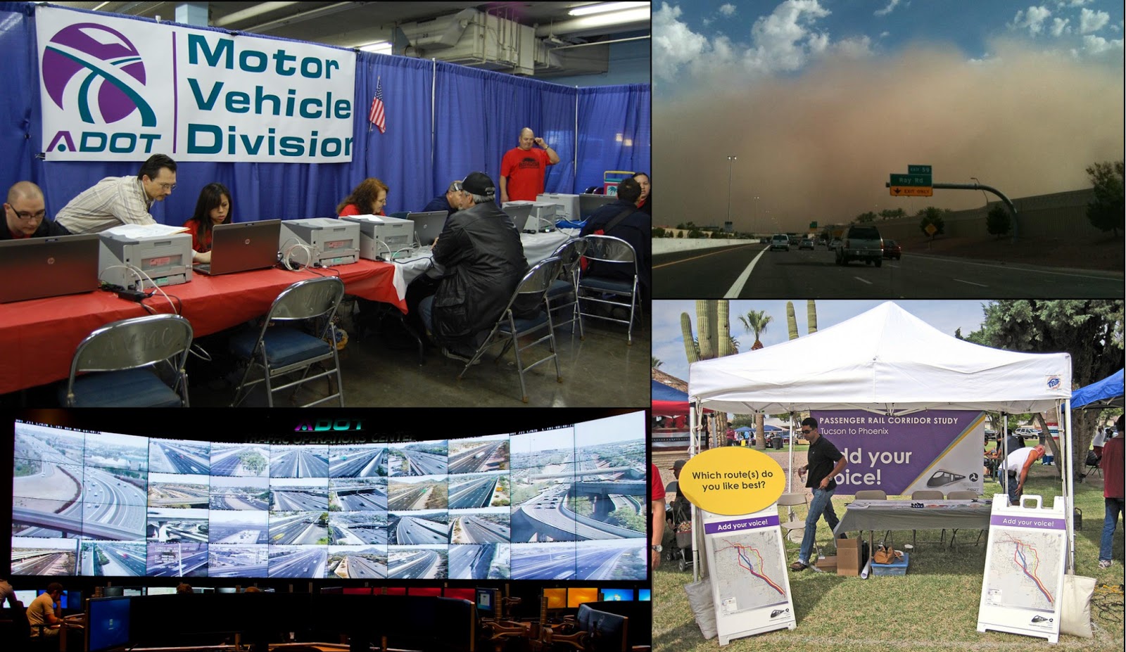
Passenger Rail Corridor Study
During the past year, ADOT identified six potential rail alternatives and one express bus alternative that could link Phoenix and Tucson and relieve expected congestion along I-10 in the future. This fall, ADOT held its second public comment period to gather input from community members about what they think about passenger rail. Nearly 3,000 people filled out a survey at community events or online. ADOT expects to narrow the list to two or three alternatives in the spring of 2013. A final alternative will likely be announced towards the end of 2013.

Of course, no 2012 wrap-up would be complete without a look at the Motor Vehicle Division and Enforcement and Compliance Division …

Motor Vehicle Division
From a new process designed to increase security for hundreds of thousands of driver license customers to outreach for the homeless population, 2012 marked another busy year for the Motor Vehicle Division. While service to customers receives the most attention, revenue collection is a vital part of MVD responsibilities. This year MVD safely and efficiently accounted for nearly $1 billion in state revenue while conducting in excess of 16 million transactions in person, through the mail and online, an increase of 3 percent from one year ago. In addition to serving the general public, MVD continued to work closely with and improve services for its industry and government partners statewide, including motor carriers, motor vehicle dealers, law enforcement agencies and the courts.

Enforcement and Compliance Division
As a means of improving highway safety throughout Arizona, the Enforcement and Compliance Division has accomplished a number of milestones during 2012. Officers completed 14,137 commercial vehicle inspections that contributed to driver and vehicle safety. Enforcement and Compliance officers also weighed 7,926,224 commercial vehicles to ensure that vehicle weights are at the legal level, reducing deterioration of Arizona’s highway infrastructure. While highway safety is of utmost importance to the Enforcement and Compliance Division officers and customer service representatives, the division also generated $16,324,134 in revenue from the sale of 461,587 permits to the commercial vehicle industry. The division has also worked closely with other state, local and federal law-enforcement agencies to ensure that a broad highway safety program is implemented to secure the safety of the motoring public when traveling around and near commercial vehicles. In addition to enforcement activities, ADOT’s Executive Hearing Office resolved 18,101 cases, a 25 percent increase from last year.

But, wait … there’s more!
There are just a few more items we want to remember before we move on to 2013. These don’t necessarily fit into any category, but they’re significant nonetheless…

Pull Aside, Stay Alive
Prior to the start monsoon season, ADOT, in cooperation with the Governor’s Office of Highway Safety, the Arizona Department of Public Safety and the National Weather Service, launched a public awareness campaign urging drivers to Pull Aside Stay Alive when they encounter a dust storm. As part of the campaign, ADOT used social media to engage the public and asked people to show off their creativity by submitting short poems about the dangers of dust storms and more than 1,500 haikus were submitted in one week.

Traffic Operations Center Upgrades
In September, ADOT unveiled its new Traffic Operations Center, which underwent a $2.1 million facelift. This high-tech control center, based in Phoenix, underwent a comprehensive refurbishment, including the addition of 40 reconfigurable 55-inch flat-panel displays, providing state-of-the art tools for the 24/7 facility. The upgrades to the center’s communications system allow ADOT staff to keep an eye on traffic conditions around the state and provide options for motorists to avoid congestion.

OK … it was nice to look back, but starting next week we’ll be back to blogging about ADOT’s present and future. Thanks for following along!

27 novembre 2012

Transportation Defined: Pavement Design Life

After 300-plus blog posts, you’d think that by now we’d have covered everything there possibly is to know about pavement...

But you’d be wrong.

Certainly, it’s not from a lack of trying – we’ve blogged about quiet pavement, pavement at airports, pavement materials testing, pavement markers and even the impact weather and climate can have on pavement. Oh, and remember when we explained how our crews are able to make sure pavement is as smooth as it can be (bonus points if you can recall how a profilograph works)?

It’s just that there’s so much to know about pavement (we’re not kidding – there really is) that we haven’t even scratched the surface.

Which brings us to today’s topic: pavement design life.

Pavement design life is a term that engineers use when they’re planning to build a new road or maintain an existing roadway. They’ll also use a number of years to go along with it, for example: 10-year pavement design life, 20-year pavement design life, etc.

The phrase should not be taken to imply that a road is only being built to survive for a set number of years. What it does represent is the road’s age at which some preventative maintenance or reconstruction will be considered so the road can continue to be durable and useful for the traffic it’s serving.

“For a typical highway, we generally will design an asphalt pavement for 20 years,” said ADOT Pavement Design Group Manager Paul Burch. “It does not mean that the road’s going to be falling apart and rubble in 20 years.”

A little more on pavement design…
Burch says that when engineers want to build a road, they take a lot into consideration, including soil condition, location, expected traffic levels and the area’s climate. Once those factors are determined – and the engineers know the pavement design life they want to build for – design begins.

All those conditions play a role in how the pavement is designed. Say, for example, the road’s being built in an area that gets very cold weather. If that’s the case, engineers will adjust the asphalt pavement mix to account for the temperature extremes.

Now, what if there’s a road that was constructed decades ago that’s not serving the traffic levels very well … can it be built up to a 20-year pavement design life?

Of course it can!

“What we would do if we were to inherit a road like that is we’d start by getting soil samples to test so we can determine what the strength of the soil is. Or, we could do Falling Weight Deflectometer testing so we could determine the strength of the existing roadway and the underlying soils through a method called 'Back Calculation.' From there, we would estimate what our traffic level would be and what design life we would want to design for,” said Burch, adding that the next step would be to create a design that takes all those important factors into account.

For more on pavement, check out our previous blog posts. And, stay tuned – we promise there are more pavement posts to come!

Transportation Defined is a series of explanatory blog posts designed to define the things you see on your everyday commute. Let us know if there's something you'd like to see explained ... leave a comment here on the blog or over on our Facebook page!